

The 2026–27 “Super El Niño”: Break our climate forever? What to expect!
A powerful El Niño is rapidly developing across the tropical Pacific, and forecasters are warning that the event could become one of the strongest El Niños observed in the modern record.
The event is already strong enough that NOAA’s Climate Prediction Center has issued an El Niño Advisory, and the agency says there is greater than a 90% chance of a very strong El Niño during the Northern Hemisphere fall and winter of 2026–27.
The numbers are extraordinary.
During July, NOAA reported a Niño-3.4 index of +1.4°C, while the Niño-3 region reached +1.7°C and Niño-1+2 reached +2.9°C. Sea-surface-temperature anomalies in the eastern equatorial Pacific have exceeded +2°C, while subsurface temperatures have been even more remarkable, with anomalies reaching approximately +10°C at depth.
That combination has meteorologists watching the Pacific very closely.
Is this really a “Super El Niño”?
Possibly — but that isn’t an official NOAA classification.
“Super El Niño” is commonly used to describe exceptionally strong events. NOAA instead uses categories such as strong and very strong, and it evaluates the event using the Relative Oceanic Niño Index (RONI).
Under NOAA’s August forecast, the median RONI reaches approximately:
+2.47°C — September–November
+2.66°C — October–December
+2.58°C — November–January
+2.23°C — December–February
The October–December period is particularly important. NOAA currently places the probability of a historic-strength event at 69%, using a threshold of +2.5°C or greater for the three-month RONI value. NOAA’s historical comparison extends back to 1950.
So the statement that this could become one of the strongest El Niños on record is legitimate.
But it is not yet legitimate to say that it will be the strongest ever.
That’s an important distinction.
Could it beat 1997–98 or 2015–16?
That’s the question scientists will be watching over the next several months.
The great El Niño events of 1997–98 and 2015–16 are among the strongest in the modern observational record. NOAA’s current forecast is concerning because the predicted RONI values are entering territory associated with historically exceptional events.
But forecasts this far ahead contain uncertainty.
The Pacific atmosphere and ocean have to remain coupled in the right way for the event to reach its maximum potential. NOAA specifically notes that stronger El Niños generally increase the likelihood of characteristic impacts, but they do not guarantee them everywhere.
In other words:
A record-strength El Niño does not automatically mean record-breaking weather everywhere.
The location of the jet stream, blocking patterns, atmospheric rivers, Gulf moisture and other shorter-term factors will determine what individual regions actually experience.

How long will El Niño last?
This is another area where the forecast is becoming increasingly interesting.
NOAA expects El Niño to continue through the Northern Hemisphere winter of 2026–27, and its latest outlook indicates that the event should persist into early spring 2027. The International Research Institute for Climate and Society similarly shows extremely high probabilities of El Niño continuing into early 2027, followed by a rapid weakening signal during spring.
NOAA’s August probability outlook gives:
December–February 2026–27: 100% El Niño
January–March 2027: 100% El Niño
February–April 2027: 97% El Niño
March–May 2027: 82% El Niño
Those numbers don’t mean scientists know the exact day El Niño will end. They mean the odds strongly favor El Niño conditions continuing through winter and weakening during spring 2027.
The most likely timeline
Now → Fall 2026:
El Niño strengthens rapidly.
October–December 2026:
Potential peak or near-peak strength.
December 2026–February 2027:
Major North American winter impacts become increasingly likely.
February–April 2027:
El Niño begins weakening.
Spring 2027:
Transition toward ENSO-neutral becomes increasingly likely.
So if you’re asking “When will it be over?”, the best answer right now is:
Probably sometime during spring 2027, although the exact timing cannot yet be known.

Will this “break” our climate?
No.
But it could temporarily push some climate indicators to extraordinary levels.
El Niño is a naturally occurring part of Earth’s climate system. It periodically releases enormous amounts of heat from the tropical Pacific and changes the atmospheric circulation.
It can temporarily raise global temperatures, alter precipitation patterns and increase the probability of extreme weather.
But it doesn’t permanently “break” the climate system.
The bigger issue is that this El Niño is occurring on top of a much warmer global climate than existed during many historical El Niño events.
That means the same El Niño circulation can produce different consequences today than it did decades ago.
A useful way to think about it is:
El Niño is the short-term amplifier. Climate change is changing the baseline.
That distinction matters.

Who is likely to get the rain?
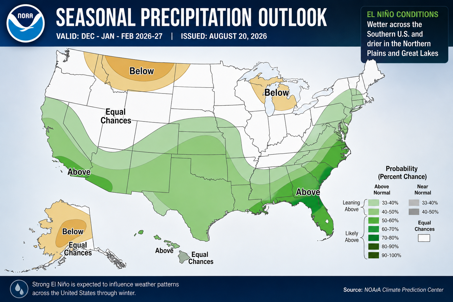
The latest NOAA seasonal outlook is showing some very important signals for the United States.
Southwest & California
One of the strongest precipitation signals is developing across the Southwest.
NOAA favors above-normal precipitation extending from Southern California and the Desert Southwest into the Great Basin and Central Rockies during the winter period. NOAA specifically says probabilities for above-normal precipitation rise above 50% across much of coastal California and adjacent southern Arizona during DJF and into late winter.
That could mean:
California: wetter
Southern Arizona: wetter
Desert Southwest: wetter
Southern Rockies: increased precipitation potential
And when temperatures are cold enough, that moisture can translate into significant mountain snow.
Gulf Coast & Southeast
This may be one of the most important regions to watch.
NOAA’s outlook shows a particularly strong precipitation signal across the Southeast, with probabilities of above-normal precipitation exceeding 60% in parts of the Southeast during NDJ, with the signal continuing into JFM.
That puts areas including:
Texas Gulf Coast
Louisiana
Mississippi
Alabama
Georgia
Florida
Tennessee
Carolinas
in a region where repeated storm systems and heavy rainfall could become an important theme.

What about snow?
This requires a major warning.
El Niño does not produce a simple “more snow here, less snow there” map.
Snow requires three ingredients:
moisture + lift + sufficiently cold air.
El Niño can dramatically increase moisture and storm frequency in certain regions, but if temperatures are too warm, that moisture may fall as rain instead.
The areas with the greatest potential for significant winter precipitation include parts of the West, Southwest, southern Rockies and portions of the southern/central United States, depending on individual storm tracks and temperatures.
Meanwhile, NOAA is favoring warmer-than-normal winter temperatures across much of the northern tier, from the Pacific Northwest toward the Northeast.
That means a strong El Niño does not automatically translate into a snowy winter across the northern United States.
The best snow opportunities may come from individual storm systems rather than a blanket seasonal signal.

And then there’s the tornado question
This is where things get especially interesting for storm watchers.
El Niño can alter the jet stream and storm track, increasing the frequency of storm systems across the southern United States during portions of the cool season.
Historical research and NOAA information indicate that strong El Niño conditions can favor increased tornado activity in portions of the Gulf Coast and Southeast, particularly during late winter.
The most interesting areas to watch include:
Texas → Louisiana → Mississippi → Alabama → Tennessee → Georgia → Florida
However, there is a crucial caveat:
This does NOT mean NOAA is predicting a specific tornado outbreak.
Seasonal ENSO relationships are probabilities, not individual storm forecasts.
NOAA research has also found that ENSO phase does not systematically determine total U.S. tornado frequency. What can change is the geographic and seasonal distribution of tornado-favorable environments.
That means the question isn’t necessarily:
“Will there be more tornadoes?”
It may be more useful to ask:
“Where does the tornado threat tend to shift during a strong El Niño?”
And the answer increasingly points toward the southern and southeastern United States during the cool season, particularly later in winter.

Why the Pacific matters so much
El Niño begins thousands of miles away from the United States.
Warm water develops across the tropical Pacific, particularly near the equator.
That warm water changes where thunderstorms develop.
Those thunderstorms release enormous amounts of energy into the atmosphere.
The resulting changes propagate through the atmosphere and alter the jet stream, which changes where storms travel across North America.
That’s how water temperatures in the Pacific can ultimately influence:
California rainfall → Texas thunderstorms → Southeast tornadoes → Northeast winter storms.
It’s one of the most extraordinary connections in atmospheric science.

The biggest story may still be ahead
The most important period could be October through February.
NOAA expects El Niño to strengthen through the end of 2026, and its current forecast puts the greatest probability of an exceptional event during the fall and early winter.
If the forecast verifies, the winter of 2026–27 could become one of the most consequential El Niño winters of the modern era.
But meteorologists aren’t calling it a guaranteed record yet.
And that’s exactly what makes the next few months so interesting.
The Pacific is heating.
The atmosphere is responding.
And the strongest part of the event may still be ahead.

SEO Keywords
Primary keywords:
El Niño 2026, Super El Niño 2026, El Niño winter 2026-27, strongest El Niño ever, El Niño forecast 2026, El Niño weather forecast
Long-tail keywords:
How strong will El Niño 2026 be?
Will El Niño be the strongest ever?
When will El Niño 2026 end?
El Niño winter forecast 2026 2027
Where will El Niño bring rain?
Where will El Niño bring snow?
El Niño tornado forecast
El Niño Oklahoma weather
El Niño Texas tornadoes
El Niño California rainfall
El Niño Southeast severe weather
El Niño climate change
Super El Niño United States