
WEATHER: Cold Front Brings Mountain Snow, Freezing Temperatures and a Major Autumn Cooldown

DENVER, Colorado — October 14, 2026 — Winter is making an early appearance across parts of the Rocky Mountains as a powerful weather system brings mountain snow, chilly rain and freezing temperatures. Meanwhile, millions of Americans enjoying unusually warm autumn weather across the central and eastern United States could soon feel a dramatic change.
The National Weather Service Weather Prediction Center says unsettled weather is moving into the West, with rain, mixed precipitation and snow at higher elevations. A developing low-pressure system moving toward the Four Corners region is expected to bring another round of cold, unsettled conditions through the middle of the week.
Rocky Mountains Prepare for Snow and Freezing Temperatures
Colorado, Utah and Wyoming are among the states expecting mountain snowfall as colder air moves across the region.
The Weather Prediction Center reports that the highest elevations of the central Rockies could receive significant additional snowfall. In parts of Utah and Colorado above 10,000 feet, forecast probabilities favor at least 8 inches of additional snow, with locally higher totals possible in favored mountain ranges.
Snow levels are expected to fall as the system progresses, potentially bringing lighter accumulations to elevations around 6,500 to 7,000 feet in parts of the region.
The cold will also create concerns at lower elevations. Freeze warnings are in effect in portions of the central Rockies and the Dakotas, where temperatures are expected to fall below freezing.
Travelers heading over mountain passes should prepare for slick roads, reduced visibility and rapidly changing driving conditions.
Summerlike Warmth Set to Give Way to Autumn Cold
The cold weather will not remain confined to the mountains. A surge of chilly Canadian air is expected to spread across much of the central United States later this week, pushing a cold front farther south and bringing temperatures closer to seasonal autumn averages.
Parts of the Midwest and Southeast could remain unusually warm for several more days before the cooler air arrives. Some locations may even approach daily temperature records before the pattern changes.
The National Weather Service’s extended forecast also highlights a broad frost and freeze threat expanding from the Plains toward the Midwest and eastern United States over the weekend and into early next week.
For gardeners and farmers, the timing matters. Sensitive plants may need protection before temperatures fall, particularly in areas that have not yet experienced a seasonal freeze.
More Than Just a Temperature Drop
The changing weather pattern could bring several hazards at once. While the West deals with mountain snow and freezing temperatures, repeated rounds of heavy rain and thunderstorms are expected across portions of the central and southern Plains.
Some storms could produce damaging winds, large hail and isolated tornadoes. Heavy rainfall may also cause localized flash flooding, particularly where storms repeatedly cross the same areas.
This contrast highlights the wide range of weather unfolding across the country: early-season winter conditions in the mountains, potential flooding in the Plains and lingering warmth farther east.
What Happens Next?
Forecasters will be watching how quickly the colder air spreads east and how far south freezing temperatures reach. The most immediate concerns include mountain travel, overnight freezes and the potential for frost damage.
The broader cooldown is expected to develop through the latter part of the week, with frost and freeze concerns increasing in parts of the country over the weekend.
Bishop Broadcast Weather Update: After an unusually warm stretch in parts of the United States, a change of season is approaching. From snow-covered Rocky Mountain peaks to the first widespread autumn freezes, residents should prepare for colder conditions and keep an eye on local forecasts.
Forecasts can change as the system develops. Check the latest National Weather Service advisories for local snowfall, frost and freeze information.
SEO keywords
Cold front October 2026, Rocky Mountain snow forecast, Colorado mountain snow, freezing temperatures, autumn cold front, Canadian cold air, first freeze forecast, frost warnings, Utah weather, Wyoming weather, Midwest temperature drop, eastern United States cold front, National Weather Service forecast, breaking weather news.

Tropical Storm Trudy Could Rapidly Intensify Into a Major Hurricane Near Mexico

EASTERN PACIFIC — October 14, 2026 — Tropical Storm Trudy is drawing attention from forecasters as it moves across the eastern Pacific, with the National Hurricane Center warning that the storm could rapidly intensify into a major hurricane over the coming days.
As of Tuesday afternoon, October 13, the National Hurricane Center reported that Trudy had maximum sustained winds of approximately 40 mph and was moving northwest. The storm was located several hundred miles south-southeast of Acapulco, Mexico.
Forecast guidance indicates that Trudy could strengthen significantly. That possibility makes its future track and intensity especially important for communities along Mexico’s Pacific coast.
Why Rapid Intensification Matters
Rapid intensification occurs when a tropical cyclone’s maximum sustained winds increase by at least 30 knots—approximately 35 mph—within 24 hours.
When a storm strengthens quickly, communities may have less time to prepare for dangerous conditions. A tropical storm can evolve into a powerful hurricane, bringing stronger winds, torrential rainfall, dangerous surf and potentially life-threatening coastal flooding.
Trudy’s forecast deserves close attention because the National Hurricane Center has highlighted the potential for major hurricane strength. However, the timing and extent of any strengthening remain subject to forecast changes.
Mexico’s Pacific Coast on Alert
The National Hurricane Center has advised residents of southwestern and west-central Mexico to monitor Trudy’s progress.
Even communities outside the storm’s eventual center could experience heavy rainfall, flash flooding, rough seas and dangerous coastal conditions, depending on how the system develops.
Residents should follow local civil protection authorities and official weather warnings. Anyone living in a flood-prone area should review evacuation plans and avoid crossing flooded roads.
The Next 24 to 72 Hours Will Be Important
Forecasters will be watching Trudy’s wind speed, central pressure, forward movement and surrounding atmospheric conditions to determine whether the storm is strengthening faster than expected.
A change in its track could also alter which communities face the greatest threat.
For now, the key message is to remain alert. Trudy has the potential to become a much stronger hurricane, and residents along Mexico’s Pacific coast should not wait until dangerous weather arrives to prepare.
Bishop Broadcast Weather Update: Tropical Storm Trudy is one to watch this week. Follow official advisories for the latest information on its projected path and potential intensification.
Storm forecasts are updated regularly. The latest National Hurricane Center advisory should be consulted before publishing specific wind forecasts, arrival times or projected landfall locations.
Tropical Storm Trudy, Trudy hurricane forecast, eastern Pacific hurricane season, Mexico hurricane threat, rapid intensification, National Hurricane Center, Acapulco weather, Pacific tropical cyclone, major hurricane forecast, tropical storm tracking.

Repeated Downpours Could Trigger Flash Flooding Across Texas and the Central Plains
TEXAS — October 14, 2026 — A slow-moving weather system is raising the risk of flash flooding across parts of Texas and the central Plains, where multiple rounds of heavy rain could soak communities over several days.
Forecasters are watching a weather pattern that combines atmospheric moisture with disturbances moving across the central United States. The result could be storms that repeatedly develop over the same locations, allowing rainfall totals to climb quickly.
Why Repeated Rainfall Is Dangerous
A single thunderstorm can produce heavy rain in a short period. When additional storms follow the same path, the danger increases because water has less time to drain away.
Low-lying roads, urban neighborhoods, creeks and areas with poor drainage are especially vulnerable. Flooding can develop quickly, even in places that have not experienced significant rainfall recently.
West Texas is among the areas being monitored for several days of showers and thunderstorms. Moisture associated with Hurricane Simon is helping fuel the unsettled weather, while additional atmospheric disturbances could keep rain chances elevated.
The broader threat extends toward portions of the central Plains and the lower Missouri Valley. Oklahoma and neighboring states should also watch for changing conditions as storms move through.
What Residents Should Watch For
The greatest concern is not simply how much rain falls, but where the heaviest downpours occur and whether storms repeatedly cross the same communities.
Residents should pay attention to flood watches and warnings, avoid flooded roadways and move to higher ground if flooding threatens their location.
People traveling through affected areas should allow extra time and never assume a road is safe because the water looks shallow.
A Forecast That Could Change Quickly
The precise location of the heaviest rainfall remains important. A shift in storm tracks could change which communities receive the most rain and face the greatest flooding risk.
Weather officials will continue updating rainfall forecasts and flood guidance as the system develops.
Stay weather-aware: Repeated downpours can create dangerous flooding with little warning. Monitor official local alerts throughout Wednesday and into Thursday.
Forecast conditions and rainfall totals may change as new information becomes available.
Texas flash flooding, Central Plains flooding, heavy rain forecast, repeated thunderstorms, flood risk Texas, West Texas weather, Oklahoma rain, slow-moving storm system, flash flood safety, October 2026 weather.
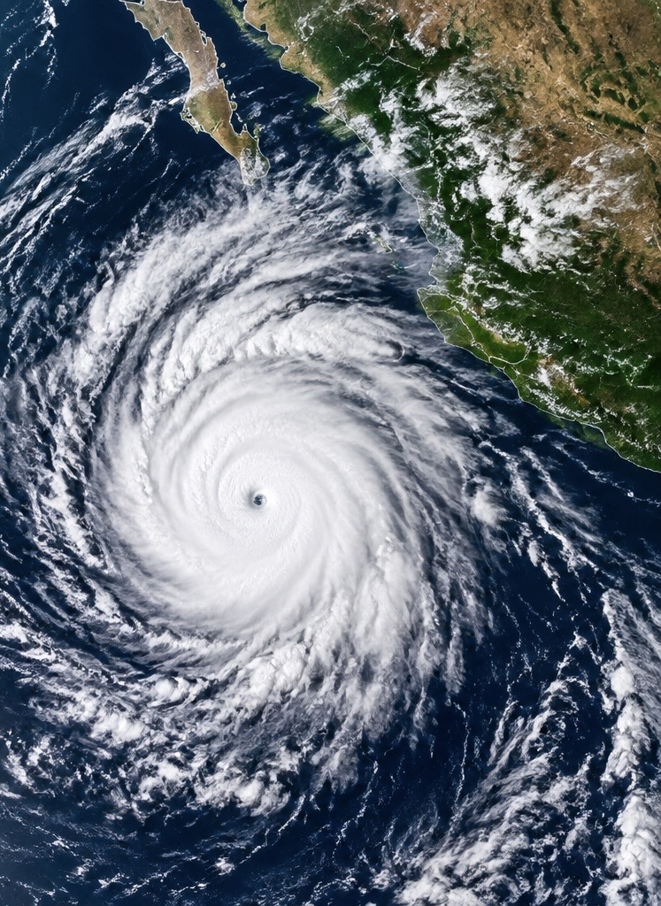
Simon A Cat 4 Hurricane
Pounds Mexico’s Pacific Coast as Dangerous Conditions Threaten Coastal Communities
The powerful hurricane is bringing destructive winds, dangerous coastal flooding and the risk of life-threatening mudslides near western Mexico.
A powerful hurricane is putting Mexico’s Pacific coast on alert as Hurricane Simon moves close to the country’s west-central shoreline. The storm remained a dangerous Category 4 hurricane Sunday, with maximum sustained winds reported at 130 mph in the National Hurricane Center’s 3 p.m. Central Time advisory.
Simon’s core was skirting the coastline near the states of Colima and Jalisco, placing coastal communities and popular tourist destinations at risk from destructive winds, heavy rain and dangerous ocean conditions.
The National Hurricane Center warned that hurricane conditions were occurring or likely along portions of the coast covered by hurricane warnings. Residents were urged to shelter in safe locations and follow instructions from local emergency officials.
Puerto Vallarta and Nearby Coastal Areas Face a Dangerous Night
The storm’s proximity to land is especially concerning for communities near Puerto Vallarta and Cabo Corrientes.
Even when a hurricane’s eye remains offshore, powerful winds and bands of heavy rain can affect communities along the coast. Dangerous waves and storm surge can also push seawater inland, flooding low-lying areas and damaging buildings near the shoreline.
Mexico’s president, Claudia Sheinbaum, urged coastal residents to remain indoors as the hurricane approached. Authorities have taken precautionary measures, including beach closures and emergency preparations, as the storm’s most dangerous conditions threaten the region.
Travelers should check directly with airlines, airports and local authorities for disruptions before attempting to travel.
Torrential Rain Could Trigger Flash Floods and Mudslides
One of Simon’s greatest threats may come from rainfall rather than wind alone.
The National Hurricane Center forecast additional rainfall of 8 to 16 inches across portions of southwestern Mexico, with isolated storm totals potentially reaching 30 inches in parts of Michoacán, Colima and Jalisco through Monday.
Those amounts could produce life-threatening flash flooding, especially where mountainous terrain forces moist air upward and concentrates rainfall over steep slopes.
Rapid runoff can overwhelm drainage systems, flood roads and carry mud, rocks and debris into communities below. Landslides are a particular concern in areas where heavy rain saturates hillsides.
Residents should avoid riverbanks, mountain roads and low-water crossings during periods of heavy rain.
Dangerous Surf and Storm Surge Add to the Threat
Simon is also generating large and potentially destructive waves along Mexico’s Pacific coast.
Storm surge can push ocean water onto normally dry land, while powerful surf can damage coastal structures and flood beachfront properties. Strong rip currents may persist even after the hurricane moves away.
Beaches and waterfront areas should be avoided wherever authorities have issued restrictions or hazardous-surf warnings.
What Happens Next?
As of Sunday evening, the National Hurricane Center continued to track Simon near Mexico’s west-central coast. Forecasters expected the storm to weaken, although it was still forecast to remain a hurricane as it moved near the coast and potentially farther offshore.
The precise impacts will depend on the storm’s track, how closely its core interacts with land and how much additional rain falls over vulnerable areas.
Residents should follow official warnings from Mexico’s civil protection authorities and the National Hurricane Center rather than relying on a single projected track.
The bottom line: Hurricane Simon remains a serious threat to western Mexico. Destructive winds, storm surge, torrential rainfall and possible mudslides could affect communities even if the storm’s center does not make a direct landfall.
SEO keywords
Hurricane Simon, Hurricane Simon Mexico, Category 4 hurricane, Mexico Pacific coast hurricane, Puerto Vallarta hurricane, Jalisco weather, Colima flooding, Mexico storm surge, hurricane landfall forecast, October 2026 hurricane news, tropical cyclone updates
Isaias Remnants: Flood Danger Remains Across the Appalachians and Mid-Atlantic
Heavy rain, rising rivers and possible flash flooding remain concerns as the storm’s remnants move northeast.
The winds have weakened, but the danger is not over. The remnants of Hurricane Isaias continued moving across the eastern United States Sunday, bringing heavy rainfall and renewed flooding concerns to portions of the Appalachians, the Carolinas and the Mid-Atlantic.
According to the National Weather Service, the flash-flood threat was decreasing Sunday, but isolated flooding remained possible in areas that received heavy rainfall. Flood watches and warnings were in effect in parts of the southern and central Appalachians. Source: National Weather Service
Rivers Rise as Heavy Rain Soaks the Mountains
Western North Carolina was among the areas dealing with significant rainfall. Some weather stations in the region reported approximately 5 inches of rain over 24 hours, while one station near Enola recorded 9.57 inches, according to reporting from the Associated Press.
The combination of saturated ground, steep mountain terrain and rising streams can turn heavy rainfall into a dangerous situation quickly. Roads may flood, water can rise rapidly in low-lying neighborhoods, and runoff can trigger landslides on unstable slopes.
Even as rainfall begins to diminish, rivers and creeks can continue rising as water drains from higher elevations into surrounding communities.
Storm Damage Reported Along the Gulf Coast
Isaias made landfall near Destin, Florida, on Friday as a Category 2 hurricane. Its powerful winds damaged buildings, tore roofing from structures and brought down trees across parts of the Florida Panhandle and southern Alabama.
The Associated Press reported at least four deaths linked to the storm and widespread power outages affecting hundreds of thousands of customers.
Emergency crews and relief organizations have been working to help residents recover, while some communities continue dealing with damaged buildings, debris and disrupted services.
Could Tornadoes and Dangerous Surf Still Be a Concern?
The storm’s circulation and associated weather systems can continue producing hazards even after a tropical cyclone loses its hurricane status.
Forecasters warned Sunday that a few tornadoes were possible across portions of Virginia and North Carolina. Dangerous surf and rip currents were also concerns along parts of the Gulf Coast and southeastern Atlantic coastline.
Residents should not assume conditions are safe simply because the storm has weakened. Flooded roads can conceal dangerous currents, and even shallow moving water can sweep away a vehicle.
What Happens Next?
Isaias was classified as a post-tropical cyclone Sunday, with maximum sustained winds of about 25 mph. The National Weather Service forecast the remaining system to continue moving northeast before dissipating.
The immediate concern is shifting from hurricane-force winds to the effects of heavy rainfall, flooding and lingering storm damage.
People in affected areas should monitor local weather alerts, avoid flooded roadways and follow evacuation instructions if authorities issue them.
The bottom line: Isaias may be losing its strength, but its final impacts could still be dangerous. For communities across the Appalachians and Mid-Atlantic, the next concern is how quickly rivers fall and how much additional rain reaches already vulnerable areas.
SEO keywords
Isaias remnants, Hurricane Isaias aftermath, Appalachian flooding, North Carolina flooding, Mid-Atlantic weather, flash flood warnings, Florida hurricane damage, October 2026 weather news, tropical storm aftermath, National Weather Service alerts
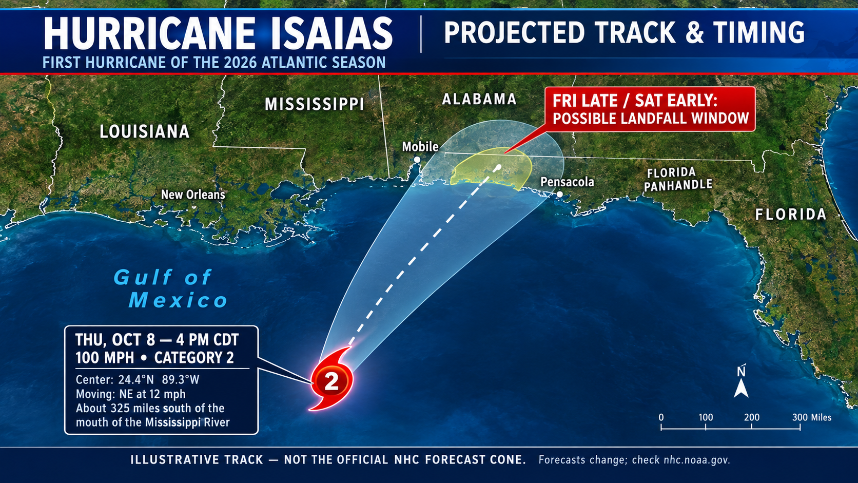
Isaias Breaks Atlantic with First Hurricane!Arrives After an Unusually Quiet Year!
Hurricane Isaias Roars to Life as a Cat 3 Hurricane ! The Atlantic Season’s First Hurricane
After months of waiting, the Atlantic hurricane season finally has its first hurricane of 2026 — and it is heading toward the U.S. Gulf Coast.
Hurricane Isaias strengthened over the warm waters of the Gulf of Mexico, becoming the season’s first hurricane on Thursday, October 8. The late-season development comes after an unusually quiet year, making this a storm that coastal communities cannot afford to ignore.
According to the National Hurricane Center, Isaias had maximum sustained winds of approximately 80 mph in its early Thursday morning advisory. Forecasters warned that additional strengthening was possible as the storm approached the northern Gulf Coast. Source: National Hurricane Center
A quiet season — until now
The Atlantic hurricane season officially runs from June 1 through November 30. Although tropical storms had already formed earlier this year, Isaias is the first system of the 2026 season to reach hurricane strength.
Its arrival in October is particularly notable. The first Atlantic hurricane of the year has developed more than four months into the season, highlighting just how unusual this year’s slow start has been. A strong El Niño has been one factor working against Atlantic storm development by increasing wind shear, which can disrupt developing tropical systems.
The Gulf Coast faces a serious threat
The danger extends beyond powerful winds. Isaias could produce dangerous coastal flooding from storm surge, heavy rainfall, flash flooding and extended power outages. Early forecasts called for 3 to 7 inches of rain across parts of the central Gulf Coast, with isolated totals potentially reaching 10 inches.
Residents along the northern Gulf Coast should monitor official forecasts, review evacuation instructions and prepare for possible power outages. Even communities outside the hurricane’s direct path could experience flooding or hazardous weather.
The bottom line
Isaias is a reminder that a quiet hurricane season is not necessarily a safe one. With weeks remaining before the Atlantic season officially ends, coastal residents should remain prepared and follow updates from the National Hurricane Center and their local emergency management officials.
Stay with us for continuing weather coverage as Hurricane Isaias moves toward the Gulf Coast.
SEO keywords
Hurricane Isaias 2026, first Atlantic hurricane of 2026, Hurricane Isaias forecast, Gulf Coast hurricane threat, October hurricane, hurricane landfall forecast, NOAA Hurricane Center, Florida Panhandle hurricane, Alabama hurricane threat, Mississippi storm surge, El Niño hurricane season, Gulf of Mexico weather, tropical storm updates, severe weather news, Jazz Bishop weather news
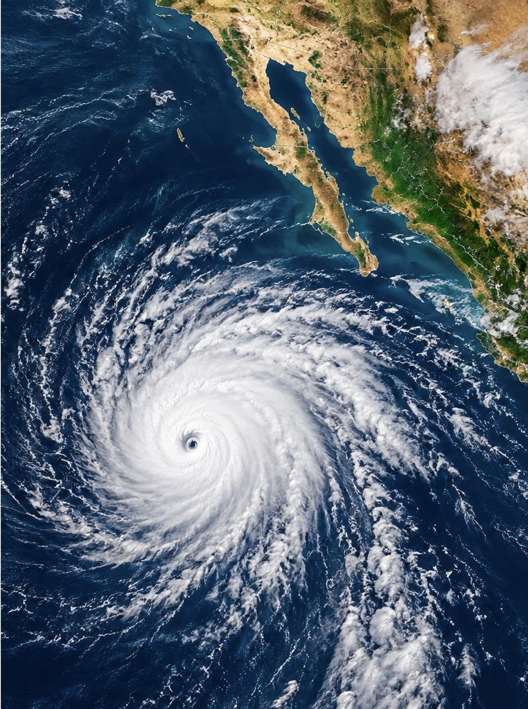
Hurricane Rachel Moves West Away From Mexico
Hurricane Rachel remains a powerful hurricane in the eastern Pacific, but the storm is beginning to move away from Mexico.
As of Sunday afternoon, Rachel had maximum sustained winds of approximately 105 mph, making it a strong Category 2 hurricane. The storm was located about 340 miles (550 kilometers) southwest of the southern tip of Baja California and was moving west at about 6 mph.
The National Hurricane Center says Rachel is expected to slowly weaken beginning Monday, although fluctuations in strength are possible before weakening becomes established. (NOAA National Hurricane Center)
Rachel’s biggest impacts are occurring along the coast rather than from a direct landfall. Large swells generated by the hurricane are producing dangerous surf, strong rip currents and hazardous ocean conditions along portions of Mexico’s Pacific coastline and the Baja California Peninsula.
The storm is expected to continue moving generally westward over the open Pacific, keeping the center away from a direct strike on Mexico.
However, coastal communities and beachgoers should continue to watch conditions because hurricane-generated swells can remain dangerous even when a storm is hundreds of miles offshore.
Rachel is another sign of an unusually active eastern Pacific hurricane season. The storm briefly reached Category 3 strength earlier in its life cycle before weakening somewhat.
Meanwhile, meteorologists are also watching another disturbance south of Mexico that has a high chance of developing later this week, meaning the eastern Pacific could remain busy even after Rachel moves farther offshore. (National Hurricane Center)
Sources: National Hurricane Center and NOAA. (NOAA National Hurricane Center)

Super Typhoon Choi-Wan Strengthens in the Western Pacific
Super Typhoon Choi-Wan is strengthening as it moves northward across the western Pacific, far east of the Philippines.
As of Monday, October 5, Choi-Wan had maximum sustained winds of about 195 km/h (120 mph), with gusts reaching 240 km/h (149 mph), according to the Philippine Atmospheric, Geophysical and Astronomical Services Administration.
The powerful storm was located roughly 2,600 kilometers (1,620 miles) east-northeast of extreme northern Luzon and was moving north at about 20 km/h.
Although the center of Choi-Wan is remaining well offshore, the storm is already affecting weather across parts of the Philippines. Its broad circulation and trough are producing heavy rain and thunderstorms across portions of Visayas and Mindanao, where flash flooding and landslides are possible.
Choi-Wan is expected to continue moving north and eventually curve toward the northeast. Forecast guidance indicates the typhoon should gradually weaken as it moves into higher latitudes.
The storm is also being closely watched because powerful recurving Pacific typhoons can influence weather patterns thousands of miles away. Choi-Wan’s interaction with the jet stream could contribute to significant weather changes farther north and east later this week.
For now, the greatest concern near the Philippines is heavy rain, flooding, landslides and dangerous marine conditions, while the core of the super typhoon remains over open water.
Sources: PAGASA and NOAA/NESDIS. (PAGASA)
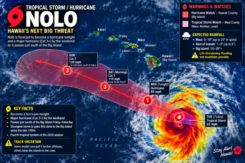
HAWAII TAKES A BEATING AS THE MOST UNUSUAL WEATHER PATTERN EVER EMERGES FROM THE SUPER El NINO
NOLO TAKES AIM AT HAWAII — STORM COULD BECOME A MAJOR HURRICANE
Tropical Storm Nolo is rapidly strengthening south of Hawaii, and forecasters are warning that the storm could become a major hurricane as it approaches the Big Island this weekend.
As of Thursday afternoon, Nolo had maximum sustained winds of about 70 mph and was located roughly 285 miles south of South Point on the Big Island.
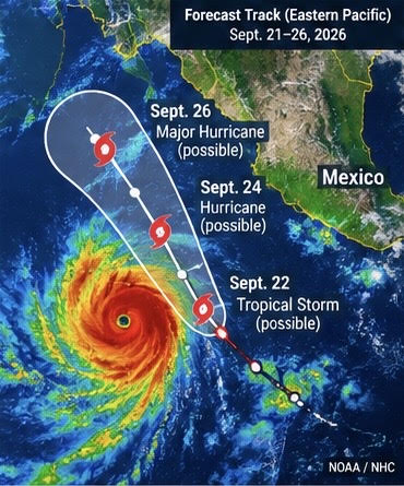
Rapid Development Expected Off Mexico
Tropical Depression South of Mexico Could Rapidly Intensify Into a Major Hurricane
A tropical system south of Mexico is rapidly organizing, and forecasters are warning that it could become a major hurricane within days.
The system, designated Tropical Depression Seventeen-E, was located about 285 miles south of Manzanillo, Mexico, Sunday afternoon.
The National Hurricane Center reported maximum sustained winds of about 35 mph, but conditions around the depression are highly favorable for strengthening.
Rapid Intensification Possible
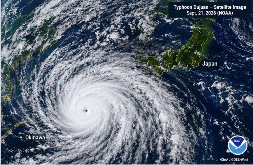
Typhoon Dujuan Threatens Japan
Typhoon Dujuan Threatens Japan With Torrential Rain and Violent Winds
Japan is bracing for Typhoon Dujuan as the powerful storm approaches the country’s eastern coast, threatening heavy rain, violent winds, flooding and dangerous waves.
Dujuan is expected to make its closest approach to eastern Japan on Monday, September 21, putting the Kanto region—including the Tokyo area—on alert during Japan’s Silver Week holiday.
The Japan Meteorological Agency says the storm is expected to pass close to the Kanto-Koshin region Monday afternoon and evening before accelerating northeastward.
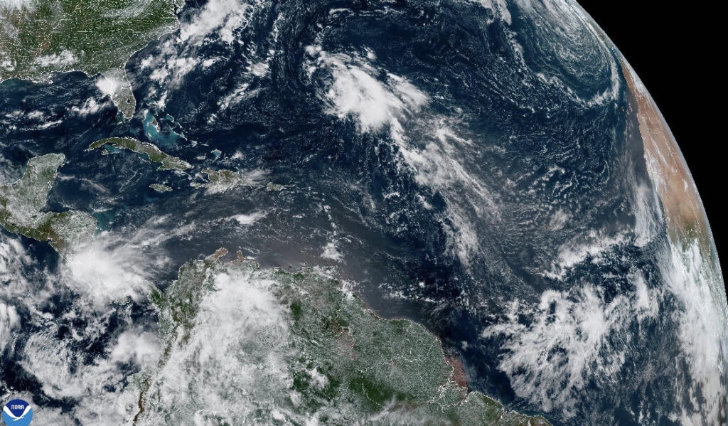
A Historic Standstill in the Atlantic
For a basin that normally becomes increasingly active through August, September and early October, the 2026 Atlantic hurricane season has reached an extraordinary milestone: not a single hurricane has formed.
And now, something interesting is being watched in the central Atlantic.
The National Hurricane Center reported Thursday morning that there were no tropical cyclones currently in the Atlantic basin. However, forecasters are monitoring a disturbance several hundred miles east of Bermuda that has a 40% chance of developing into a tropical cyclone over the next several days.
A record-breaking lack of hurricanes
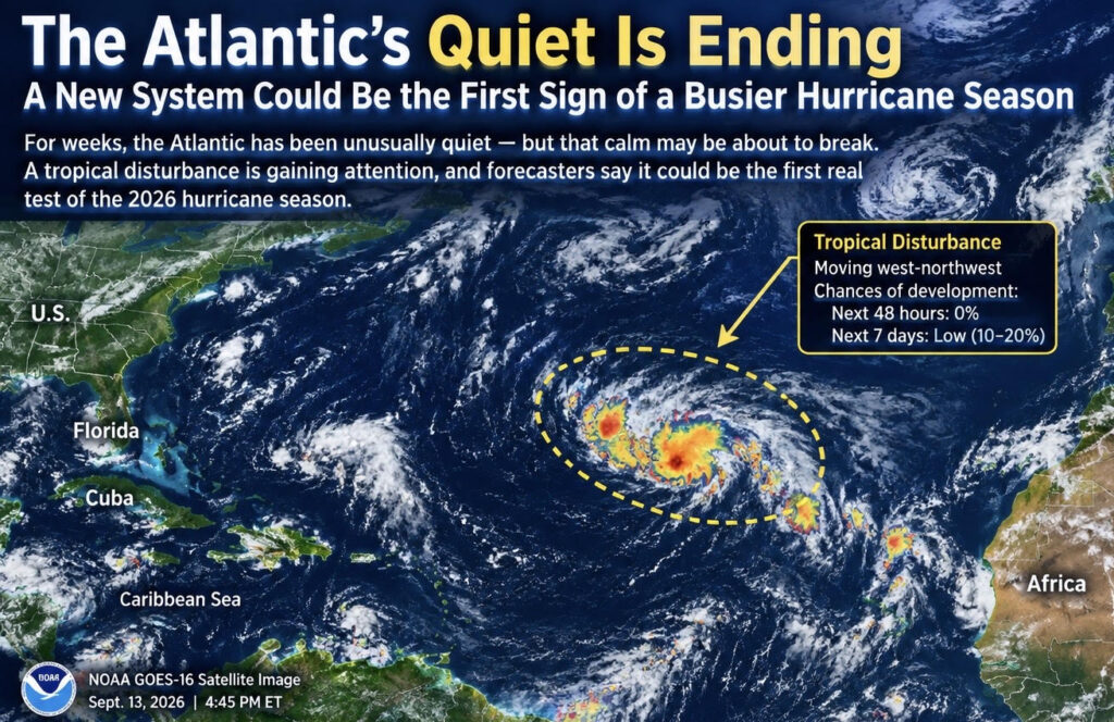
The Atlantic’s Long Quiet Stretch May Finally Be Coming to an End
For weeks, the Atlantic hurricane season has been remarkably quiet.
Now, forecasters are watching a new disturbance in the central Atlantic that could signal the beginning of a change in the basin.

Long Beach Flooding: Hurricane-Driven Waves Tear Into California Coast
Long Beach, California, has been hit by serious coastal flooding and erosion as powerful waves battered the Alamitos Peninsula, damaging the shoreline and threatening beachfront homes.
The flooding was not simply caused by heavy rain. The main culprit was Hurricane Marie, which stayed offshore but generated a powerful swell that traveled toward Southern California. The National Hurricane Center warned that Marie would continue producing dangerous surf along the Southern California coast.

Indonesia Volcano Eruption Disrupts Flights Across the Region
A powerful eruption of Anak Krakatau in Indonesia has caused major disruptions to air travel, with volcanic ash spreading across parts of Java and Sumatra.
The eruption forced authorities to temporarily close eight airports, including Jakarta’s major Soekarno-Hatta International Airport. Volcanic ash reached altitudes of up to approximately 50,000 feet, creating a serious aviation hazard because ash can damage aircraft engines and other critical systems.

Three Storms, One Unusual Pacific
Three tropical cyclones spinning across the Pacific at the same time. Cick into post for video and full story! Radar imagery of an extraordinary scene this week as Lowell, Karina and Marie occupied the Pacific simultaneously. For weather watchers, seeing three systems developing together is a rare and fascinating sight.

Philippines Flooding: Communities Facing a Relentless Monsoon
The Philippines is facing another serious round of flooding as the Southwest Monsoon, known locally as Habagat, continues to bring heavy rainfall across parts of Luzon and the Visayas.
The latest flooding has affected communities across Central Luzon, Metro Manila, CALABARZON and other areas. Government officials and emergency agencies continue to monitor flooded communities, evacuate residents and deliver assistance to people cut off by rising water.